1-280×260
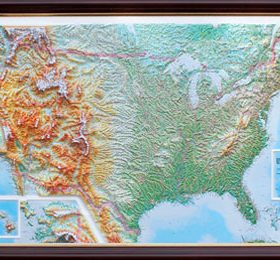
High Raised Relief Map displaying over 10,000 Place Names
1. Size: (unframed), 44 x 32 inches
2. Scale: 1:4,865,000, or 1″ = approx. 75 miles
3. Vertical Scale: Average height of mountains is 1″ to 3″ from the surface.
4. Vertical Exaggeration: 35 times
5. Territorial Coverage: All of US with insets for Alaska and Hawaii.
a. North includes some of Canada
b. South includes Cuba